The big idea
Earth's outer shell isn't one solid piece. It's broken into about 15 major plates plus dozens of smaller ones, each of which moves slowly and independently. They drift a few centimeters per year, propelled by heat-driven convection in the much thicker mantle below.
Plate motion is the answer to a long list of questions:
- Why do continents fit together like puzzle pieces (the Atlantic coastlines of Africa and South America)?
- Why are there mountain ranges in specific places?
- Why do earthquakes happen along certain lines and not others?
- Why are most volcanoes on certain edges of continents and ocean basins?
- Why do fossils of the same dinosaurs appear in Africa and South America?
The theory of plate tectonics, confirmed in the 1960s, explains all of these with one mechanism.
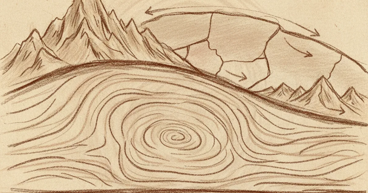
What's actually moving
Earth has three main layers by chemistry: crust (thin and hard), mantle (thick and hot), and core (iron, mostly liquid). For plate tectonics, the more useful division is by rheology (how the rock flows):
- Lithosphere: the crust plus the upper, cooler part of the mantle. About 100 km thick. Hard and brittle. This is what breaks into plates.
- Asthenosphere: the next 200 km of the mantle. Hot enough to flow slowly, like very stiff toffee. The plates ride on this.
The "plates" are pieces of the lithosphere. They float on the asthenosphere and move horizontally relative to each other.
The asthenosphere itself flows because of convection. The deep mantle is hotter than the upper mantle (heat from radioactive decay plus residual heat from Earth's formation). Hot rock at the bottom is less dense, so it rises; cooler rock at the top descends. The rising and sinking columns of mantle rock drag the plates above them along for the ride.
What happens at boundaries
The interesting geology is where two plates meet. Three things can happen:
Convergent boundaries. Two plates collide.
- If one is oceanic and one is continental, the denser oceanic plate dives under the continental plate (subduction). Examples: the Pacific plate diving under South America to form the Andes; the Pacific plate diving under Japan. Where the subducting plate melts at depth, magma rises and produces volcanoes — the Andes have hundreds.
- If both are continental, neither subducts; they crumple upward. Result: the Himalayas (India crashing into Eurasia for the last 50 million years), the Alps (Africa crashing into Europe).
Divergent boundaries. Two plates pull apart, and new crust forms in the gap.
- Mid-ocean ridges are the classic example. The Mid-Atlantic Ridge runs the entire length of the Atlantic; Iceland is its visible high point. As the plates pull apart, mantle material rises to fill the gap and solidifies into new ocean floor crust. The Atlantic is widening about 2 cm per year.
- Continental rift zones — the East African Rift, the Rio Grande Rift — are early-stage divergent boundaries that could become new oceans over tens of millions of years.
Transform boundaries. Two plates slide past each other horizontally.
- The San Andreas Fault is the most famous: the Pacific plate moving northwest past the North American plate. New Zealand's Alpine Fault is another. These boundaries don't create or destroy crust, but the friction produces earthquakes — often very large ones, as accumulated stress releases episodically.
Most earthquakes happen along plate boundaries. Most active volcanoes do too. So does most mountain-building. The pattern of plate boundaries is essentially the pattern of where geology happens.
The evidence that won
The theory wasn't accepted overnight. Alfred Wegener proposed continental drift in 1912 — the idea that continents had moved over time. His evidence:
- Continents look like they fit together (especially Africa-South America).
- Identical fossils on widely separated continents (Mesosaurus on South America AND Africa, but nowhere else).
- Identical rock formations across oceans.
- Climate evidence — ancient glacial deposits in places that are now tropical, indicating those places had been near the poles.
Wegener was correct, but he didn't have a mechanism for how continents could plough through solid ocean floor. He was rejected by most geologists for decades. He died on a Greenland expedition in 1930, his theory still in disrepute.
The case was finally settled in the 1960s, by multiple lines of evidence converging:
Magnetic stripes on the ocean floor. When mid-ocean ridge basalt cools, it locks in Earth's magnetic field direction. Earth's magnetic field has reversed many times in the past. The seafloor shows alternating stripes of normal-polarity and reverse-polarity rock, symmetric about the mid-ocean ridge. The pattern only makes sense if the seafloor is being continuously created at the ridge and pushed outward — exactly what plate tectonics predicts.
Earthquake distribution. Plotting earthquakes globally revealed sharp lines where the seismic activity was concentrated — exactly the lines where plate boundaries would have to be.
Hot spot tracks. Hawaii sits on a "hot spot" of upwelling mantle. As the Pacific plate moves over the hot spot, new volcanoes form periodically. The result is a chain of islands — and underwater extinct volcanoes — moving northwest from active Hawaii. The age of the islands matches their distance from the hot spot, all consistent with the Pacific plate moving at the inferred rate.
By the late 1960s, the case was overwhelming. Geology went from "continents are fixed" to "continents drift on plates" within a few years.
Why some boundaries are sleepy and others are not
Plates move slowly and steadily as wholes, but the boundaries are where the stress accumulates. Mostly, plates aren't quite sliding smoothly past each other — they're locked, building up elastic stress, until one big slip releases it as an earthquake.
The biggest earthquakes happen at subduction zones, where one plate is being shoved beneath another. These can produce magnitude 9+ earthquakes that release energy equivalent to thousands of nuclear bombs. The 2011 Tōhoku quake (M 9.1) and the 2004 Sumatra-Andaman quake (M 9.1-9.3) are recent examples. Both produced massive tsunamis.
Transform boundaries (like San Andreas) produce smaller but still significant earthquakes — up to about M 8. Mid-ocean ridges produce small earthquakes, mostly invisible to humans because they're underwater.
Volcanoes cluster too. The "Ring of Fire" around the Pacific is essentially a ring of subduction zones, each producing chains of volcanoes inland from the trench. Mid-ocean ridges are basically continuous lines of underwater volcanism, mostly invisible. Iceland is one of the few mid-ocean ridge segments above sea level, which is why it has so much volcanic activity for its size.
Tectonics on other planets
Earth is the only planet in our solar system with active plate tectonics that we know of. Mars and Venus have one-piece crusts. Their geology is dominated by hot spots (giant volcanoes like Olympus Mons) and impact craters rather than plate boundaries.
Why does Earth have plates and Mars doesn't? Probably two reasons: Earth is larger (more internal heat retained), and Earth has surface water that may help plate boundaries develop and stay weak. Mars cooled faster and lost its surface water; without those, its crust froze into one piece.
If plate tectonics is rare among planets, that has implications for the search for life — the carbon cycle (and therefore climate stability) on Earth depends partly on plate motion (see the carbon cycle article).
Want a 5-minute personalized course on plate tectonics with quizzes? NerdSip can generate one starting from the basics.
The future of the continents
If plate motion continues at current rates, in roughly 250 million years most continents will have collided into a single supercontinent — sometimes called "Pangaea Proxima" or "Amasia." North and South America will collide with Asia. Africa will fully merge with Europe. Antarctica may drift north. Most of the current major oceans will close.
This isn't science fiction; it's the natural extrapolation of current motions. Earth has had several supercontinents in its past (Pangaea ~300 million years ago, Rodinia ~1 billion years ago, Columbia ~1.8 billion years ago). The cycle repeats every ~500 million years or so. Future continents will form, fragment, and reform long after humans are gone.
The takeaway
Plate tectonics is the slow, steady reshaping of Earth's surface by movement of about 15 main plates, driven by mantle convection. It explains where mountains, earthquakes, and volcanoes happen, why continents look like they fit together, and how the planet recycles its outer shell. The theory was rejected for half a century, then suddenly confirmed by independent lines of evidence in the 1960s. Today it's the foundation of modern geology, and the slow but inexorable force that shapes the surface we live on.
the idea that continents are still creeping around right now, slowly, under our feet is something i will never fully wrap my head arround. great explainer
realising mountains are basically slow-motion collisions reframes every landscape i look at now. patience on a geological scale